
A river map allows us to understand various waterways that flow across our landscapes, carrying life-giving water from high mountains to the seas. India is one of the few countries that is blessed with river systems. India’s rivers are also dominant in the transportation, and Indian waterways. This post will explore the river map of India and look at the Indian river systems formed by the major rivers of India that shape our nation’s geography.
Quick Navigation
What is a River?
A river is a natural stream of fresh water flowing downhill from up higher because of gravity. They begin as little trickles on hillsides or wetland areas but grow into bigger ones by taking in more water en-route. After some time, all rivers reach a sea somewhere else. This meeting point of a river and sea is called as confluence in English and ‘sangam’ in Hindi.
What is a tributary?
A tributary is a small river that joins major river. A tributary does not directly meet a sea/ocean. Based on the direction their enter the major river, tributaries are classified into left tributaries and right tributaries.
- A left tributary enters the main river from the left side when we look at the main river from downstream or on its path to the sea.
- A right tributary enters the main river from right side when we look at the main river from downstream or on its path to the sea.
List of major rivers in India
Major rivers of India always played a crucial role in the development of civilization on their banks and the evolution of Indian river systems. Many rivers are mythologically and culturally significant for India. Here is the list of major rivers in India:
- Ganga
- Yamuna
- Saraswati
- Brahmaputra
- Cauvery
- Tapti
- Sabarmati
- Mahanadi
- Sutlej
- Beas
- Chenab
- Jhelum
- Ravi
- Krishna
- Alaknanda
- Koshi
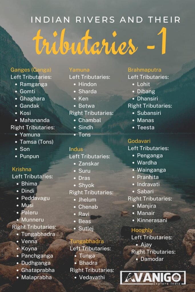
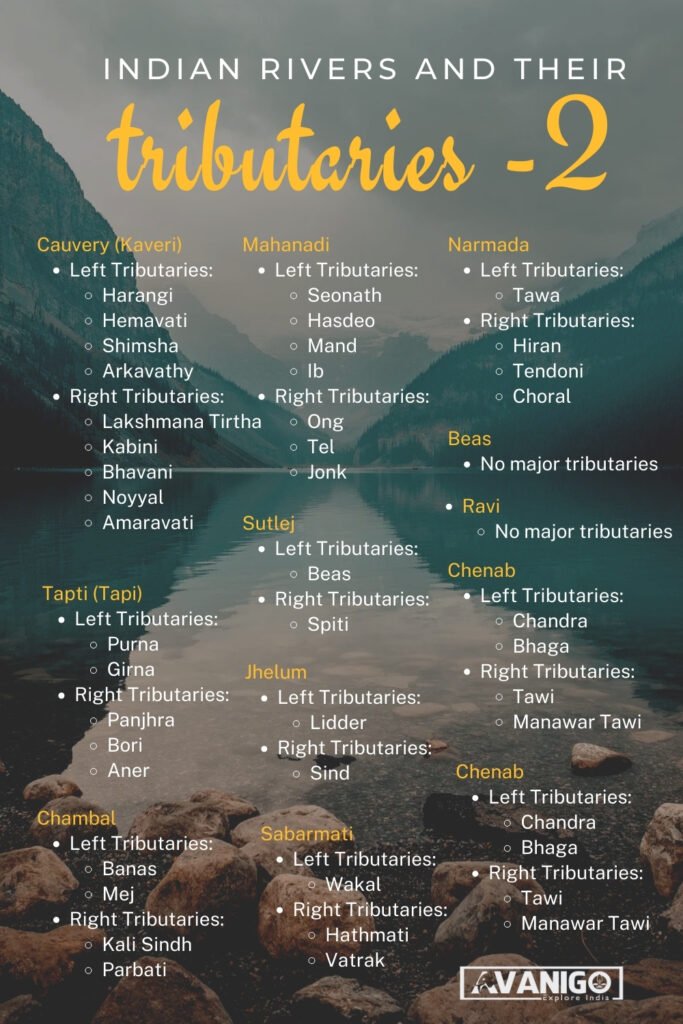
Indian Rivers and their tributaries
The major rivers of India and their tributaries are shown as under:
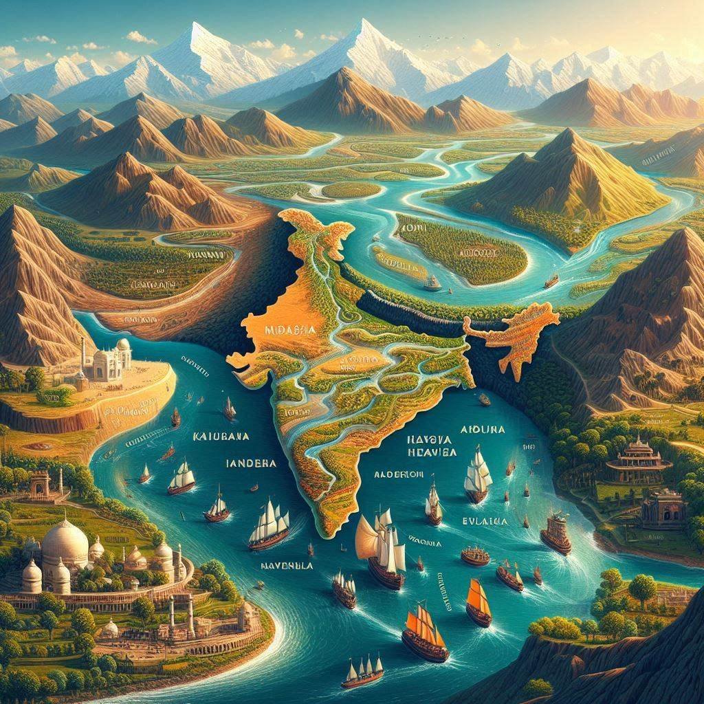
The Waterways of India
Indian river systems are very vast and rank among the world’s largest. The river map of India shows how its rivers originate from just two central regions: the Himalayan mountains up in the North and the South source located at Western Ghat mountains. Let us delve into these Indian rivers and learn more about the major rivers of India:
The Himalayan Rivers
Waterways of India, specifically the Indus, Ganges, Brahmaputra, Yamuna, and Kangsabati, have snow-capped Himalayas as their origins. Those rivers acquire essential nutrients and sediments as they pass across India due to the water that flows from these high mountain peaks after melting.
The Indus River
- The great Indus River comes from Mansarovar Lake on the top of the world, the Himalayas; it then passes through Tibet into India, where it flows to Pakistan.
- The river is among the most important ones in India as it enters Ladakh over the Zanskar mountain range before going down towards the west into J&K.
- Cutting through narrow gorges, the powerful Indus exits India around Attock to travel through Pakistan, which splits into two branches called the Panjnad before joining the Arabian Sea near the port of Karachi.
- Numerous major cities have developed on the banks of this Indus, including Leh, Srinagar, and Lahore. The famous Indus Valley Civilization thrived along the banks of this river.
- Though traversing India for a relatively short stretch, the snow-fed Indus played a vital role in irrigation and industry along its banks before increasing significantly in size due to tributaries on the Pakistani stretch.
Old and New Names of Indian Cities
The Ganges River
India’s holiest river, without a doubt, is Ganga. Ganga river originates from the icy Gangotri glacier in Uttarkhand’s Himalayas and first flows as Bhagirathi through the state before combining with Alaknanda at Devprayag to form the Ganges.
- Ganga is the largest river in India. This sacred and largest Indian river then flows to the southeast across the northern plains of this country, penetrating states such as Uttar Pradesh, Bihar, and West Bengal, where it supports more than half a billion people.
- The holy Ganges are joined en route by several significant tributaries that add to their sacred waters.
- It receives the Mandakini, Dhauliganga, and Pindar rivers in the upper stretches. In contrast, in plains areas, the Yamuna, Son, Ghaghra, Gandak, and Kosi streams boost their flow mightily before they empty through a vast fertile delta into the Bay of Bengal near Bangladesh.
The Yamuna River
The Yamuna River emerges from the Banderpoonch range in Uttarakhand from the Yamunotri glacier and flows westward across India’s northern plains. It goes through Uttarakhand, Himachal Pradesh, Haryana, Uttar Pradesh, and Delhi to meet the Ganga, India’s longest river, which holds a place of the most sanctimoniousness among its tributaries.
- Several significant tributaries meet the Yamuna on the plains journey, like the Tons, Chambal, Betwa, Sind, and Ken rivers, thereby boosting its girth considerably.
- Historically nurturing the fertile Doab region’s agriculture, today, the Yamuna struggles with pollution yet remains central to the faith of riparian dwellers.
- Holy cities like Vrindavan, Mathura, and Agra depend on this river, which signifies salvation in Hindu mythology.
The Brahmaputra River
Rising from the Chemayungdung glacier located high in the Himalayas of Tibet, this transboundary river is often called Tsangpo in its upper stretches.
- Entering India through Arunachal Pradesh, it goes by Dihang and afterward as Brahmaputra.
- Flowing southeast through many gorges and valleys, it receives water from several mountain streams like the Dibang, Siang, Lohit, and Subansiri rivers.
- The Brahmaputra River originates from the mountains to reach the fertile Brahmaputra valley plains and transforms into a braided river cutting across Assam.
The Peninsular Rivers
The Godavari River, Krishna River, Kaveri River, and Mahanadi River are major rivers in India that originate in the Western Ghats and meet the water needs of the people living in Southern India by rushing down from the Westward slopes of these mountains and directly watering areas at Deccan Plateau.
The Godavari River
Springing forth from Maharashtra’s Western Ghats at Triambakeshwar near Nashik, the Godavari flows southeast for over 1400 km, draining a massive 3,00,000 sq km basin.
- It passes through six Indian states, empowering them to become one of the nation’s largest peninsular rivers.
- In its long course, it absorbs the waters of several tributaries like the Pranhita, Manjra, Indravati, and Sabari, boosting its girth.
- Upon reaching the thickly forested regions of Telangana and Andhra Pradesh, it forms a vast fertile valley before breaking into a mighty network of distributaries emptying into the Bay of Bengal.
- Cities like Nashik, Nanded, and Rajahmundry rely upon this perennial river for irrigation, ports, and holy sites.
The Krishna River
Originating in the Sahyadris of Mahabaleshwar, this important peninsular river flows east straight across Karnataka and Andhra Pradesh. Its chief tributaries are Tungabhadra, Bhima, and Koyna-rivers joined the Krishna near Vijayapura.
- Flowing south-eastward along a deep gorge called Bedtihal, Krishna waters the rich fields of Telangana and Andhra Pradesh.
- As it approaches the happening city of Vijayawada, it splits into many channels that form a luxuriant green delta. Here, among palms, it winds up and merges into the Bay of Bengal.
- All along this holy river’s long path are ancient temples and irrigation works that water the big cities and farms along its banks.
The Kaveri River
The “Ganges of the South,” streaming 320 km to the southeast, originates from Brahmagiri mountain situated in the Western Ghats near Coorg, Karnataka, and used for irrigation in Tamil Nadu.
- As it passes through the holy cities like Srirangapatna and Madurai, it engulfs six feeder streams, thus making its way broader and mightier through the heartland of Southern India.
- Flowing past the ancient port city of Puducherry, it creates a vast fertile delta fan emptying into the Bay of Bengal near Nagapattinam.
The Narmada River
Narmada’s source is in Amarkantak, Madhya Pradesh, as she flows out of a rift valley over 1,300 km, casting aside marble cliffs in bizarre shapes while heading westbound. Besides providing water security, Narmada is known for its natural and mythical heritage.
- Near Jabalpur, Narmada forms the stunning Marcel Rocks and Dhuandhar Waterfalls.
- Legend says Lord Shiva sat here during his penance. The river flows through Madhya Pradesh and Gujarat, where it is revered during religious festivals like Narmada Jayanti.
- Regions like Amarkantak, Omkareshwar, and Sardar Sarovar have become popular tourist spots.
Protecting Our Rivers
The river map of India brings to light the importance of natural waterways through which life-giving waters flow across the landscape on their journeys to the seas. These rivers have nurtured river-valley civilizations and supported vibrant ecosystems throughout history. Let us pledge to protect this natural heritage through conservation and rejuvenation efforts so future generations may continue enjoying the gifts of India’s rivers.
Swetha is a Content Specialist, LinkedIn Branding and B2B Marketing Consultant. When she is not in the world of B2B, she researches the roots and beauty of Indian Culture and Traditions. She is the author of the book: 365 Days 365 Posts – The Guide to LinkedIn Personal Branding, available exclusively on Amazon. Connect with her on LinkedIn.